
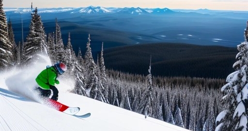
4 Days of Driving for 4 Days of Snowboarding Mt Bachelor
Last year’s Great Canada Snowboarding Adventure was the last great trip I had planned linking ski resorts together in a chain. It was by far the most resorts, the longest drive, and the most fun I’ve had on all snowboarding winter adventures, so far, but it also marked an end. There just weren’t that many resorts left I hadn’t visited, and the lost one were isolated, far, and not on any pass system.
But Mount Bachelor loomed large in the isolated pocket. After all, I had lived in Oregon, had driven through Bend (and stopped for coffee) on a different snowboarding trip years later, and had friends who raved about Eastern Oregon in general, Bend in particular, and the mountain specifically. So I planned and packed and off we went on a February trip.
The Drive
First things first, the drive is annoyingly long. You have several option to get to Bend from Denver, but the one consistently netting the shortest duration is the drive on I80. That means driving North towards Cheyenne on I25, turning left/West on I80, then driving through Wyoming to Utah. Here you switch to I84, which I knew as the Columbia Gorge freeway, until you hit the Oregon border just after Boise. The rest of the way is on rural highway US20.
At first, the thought was to do the drive in one day: leave as early as possible in the morning, brave the infinite expanse of the American West, and land at the end of a tiresome day at a rental of sorts. Then wake up early and head up the mountain. Great plan, but an even better plan was to pick a random spot on the drive and make it there the night before, so that the drive could be broken up. We picked Rock Springs, WY, since it was “only” five hours from home.
Because of work schedules, we left the evening of Thursday. As usual, the drive was cold. Thankfully, it wasn’t actively snowing and we made it to the motel in good time. The advertised hot tub didn’t exist, and I certainly could have used a little pampering. But at least we had enough time in the morning to eat the pumpkin waffles and drink the included coffee.
Friday was long and exhausting. Despite the five hour headstart, it still took twelve hours to get to Bend. We left around seven and drove endlessly. The weather was not bad and we only stopped for gas and bathroom breaks. In the process, we saw the former get more expensive as we approached the West Coast. The only notable stops were coffee breaks, because we saw some really nice shops. I am going to mention favorably Grounds for Coffee in Ogden, UT and Sorbenots in Ontario, OR.
Of the drive, the most memorable part was the Snake River valley, which is most of the Idaho share of it. I had already driven it twice and remembered it very fondly, but this time it was particularly amazing. The weather was spectacular and, despite it being February, there was no snow on the ground, making the landscape more varied than the monotone white of the past times.
I’ll mention something odd: despite having lived in Oregon only for a year and a half, and over a quarter century ago, strangely as soon as we crossed the border, I felt right back at home. Oregon has that quality: it is quirky enough to be easily distinguished from nearby places, but the quirks are all positive, attempts to make the world better, regardless of what other people think.
Bend
Getting into Bend at night was not pleasant. The city is not large by any means, but it is beset with an insane number of roundabouts even on major arteries. I know that those are supposed to be good for the flow of traffic and lower accident rates - great things! But navigating them in an unfamiliar place is confusing, since once in the turn, you can’t really tell what straight ahead means any longer. Night driving makes that more difficult, of course, since it all looks the same.
We had picked lodgings in River West, the neighborhood on the West side of the river (Downtown is East). That was specifically because we wanted to be as close as possible to the mountain, while also being close to the mountain shuttle. For mysterious reasons, that shuttle only has two stops: one to the East of town, the other in River West. There are no more stops closer to the mountain, even though there are plenty lodging opportunities.
We had heard about the insane amount of snow that Mount Bachelor gets, so we wanted to make sure we didn’t have to drive. The we’d be in a busy neighborhood was fine, as it meant we could easily go out and have fun.
In the end, we got the best of all worlds: an entire half of a duplex, with garage, that was so quiet we heard nothing at all. But a five minute walk to the bakery and coffee shop, to an Italian restaurant and brewery. All in all, a great choice!
Day 1
There was no fresh snow, it was a Saturday, and we jumped into the car as early as we could manage. We assumed it was going to get crowded and we didn’t want to be turned away at the parking lot and sent to some far away shuttle parking as they do in Keystone!
The drive was amazing. The road was clear, the sky was blue, and the drive short. From the duplex to the parking lot it was just 21 miles of easy drive. The road is mostly a two-lane highway, except for the last portion, but traffic was moving apace. Things got amazing as we approached the mountain: most of the drive is in a dry forest, but eventually the mountain comes into view, and what a sight it is! Incidentally, by the time you see the mountain, you are almost there.
Traffic started backing up, and it was all snow seekers. Apparently, blue skies are rare enough at the Bach that people drove extra far to get a day of sunshine, which made it extra crowded. Most people stuck to the right lane of the now four-lane highway because the left lane was still crusted over. You should know that the left lane is legal and goes all the way to the parking lot, but that you will be honked at if you pass traffic. Of course, we didn’t know so we slogged it all the way on the right lane.
The highway ends at Mount Bachelor’s main parking lot, so it’s not like you can get lost. The lot itself is pretty big, large enough to accommodate the crowds of a mid-February sunshine Saturday. There are smaller (much smaller) lots before the main lot, at Sunrise Lodge, which connects to the rest of the mountain through Sunrise Express. If the lots are open, it’s worth parking there.
The main lodge, West Village Lodge, was bigger than expected. It consists of several buildings, with the actual food place / lodge dominating. The deck faces the slopes and the mountain and is an amazing place to sit and enjoy the beauty of the location.
The first order of business was to get on the lift, Pine Marten, from which we could access the rest of the mountain. The line was long, but moved fast. In particular, in a quirk of Oregonian proportion, instead of opting for the usual maze setup, the six lines fed into a long feeder. When the feeder was empty, the first row of each line poured into the feeder and then moved ahead, rounding into the lift.
Our lift kahuna was a gentleman wearing a Viking outfit and shorts only. He was a riot, with his missing right horn, the booming voice, and the amusing takes. He’d love taking pictures with people, talking with kids (who seemed baffled and intrigued, wondering why he didn’t mind not wearing pants), and (by far most importantly) giving us preferential treatment because of my helmet mohawk. (He did so only once, but I am not complaining.)
General Layout
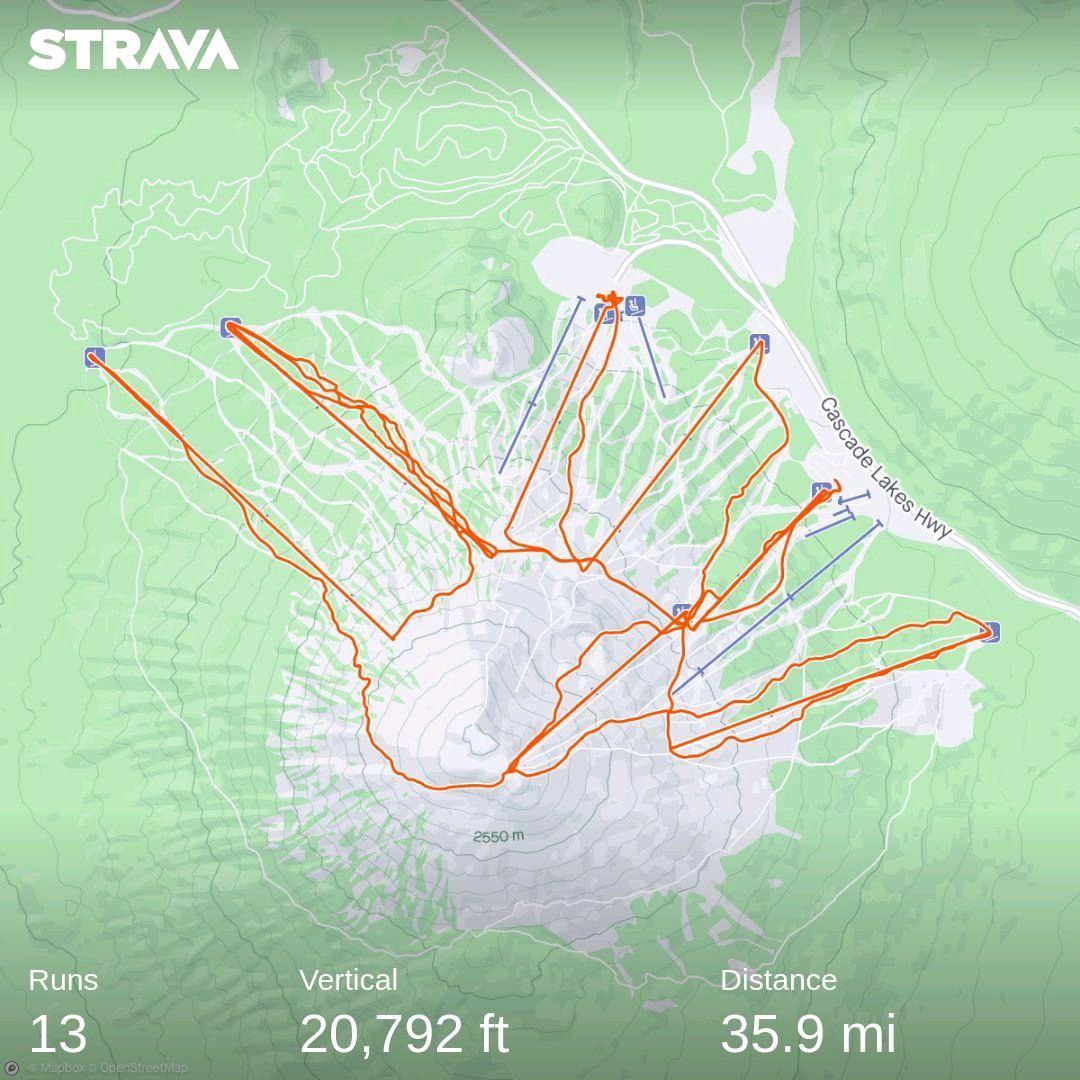
Mount Bachelor is a stratovolcano. Oregon’s main mountain chain is the Cascades, a volcanic arc that goes all the way from Southern Canada to Norther California. It has some very remarkable mountains, standouts both in height (Mount Ranier and Mount Shasta are both Fourteeners, but their base is very low altitude) and beauty. Mount St Helens in Southern Washington state (the mountain that exploded in 1980) is on the arc, as is Mount Hood overlooking the Columbia River Gorge, and Crater Lake, which is the lake left by the explosion of Mount Mazama.
Being a volcano, Mount Bachelor is in essence a cone that dominates the area around it. To the North of it, a series of other volcanoes in a group named The Sisters (no names, just North, Middle, South Sister). In the distance, on a clear day like this, you can see Mount Jefferson to the North and maybe even Mount Hood. The view to the South has less prominent landmarks, as do the views along the parallel.
The ski area itself makes runs available all around the mountain. You can pick your line from the summit and descend whichever way you want. The named runs and infrastructure, though, are limited to the quadrant from North-West to North-East, where the snow stays fresh longest and where the highway comes in.
The lifts are all great. There is a single slow lift, Red Chair, that wasn’t in operation when we got there. Everything else is some shade of express lift, down to the farthest from the center.
Infrastructure is great, in general. There are three lodges for food and drink - the two already mentioned, and a third one at the top of Pine Marten, from which it takes its name. Moving about on the mountain is easy, especially going West to East, where a cat track connects everything from Northwest lift to Cloudchaser, the Eastern-most.
Day 1 - Part 2
At the top of Pine Marten, we tried figuring out what to do. The idea was to stick to one side of the mountain on one day, then continue to the other side the next, and then decide what to do for the rest of the stay based on the first two days.
We decided to head to the East, as Cloudchaser had been advertised heavily as The Place To Be, and access was easy. We took the cat track (Summit Crossover) until we hit the top of Sunrise lift where it connects to the bottom of Summit lift. Chaos and mayhem ensued, as the line for Summit was so long, it cut the crossover, making navigation really hard. There were staff directing motion, making people in line wait for passing traffic, then having them roll down slowly to the other side of a channel they had created.
We barely made it to the other side, mostly because the area is flat and it’s hard to navigate without speed. Then it was time to head East on a very, very green run to hit the bottom of Cloudchaser.
This lift is such a recent addition to the resort that it doesn’t appear on the Google Maps rendition to date. You can see it in the satellite pictures, though. Bachelor resort is very proud of their accomplishment here, opening up blue / intermediate slopes on this side of the mountain. For reasons defying understanding, there is no separate parking lot associated with the lift (maybe a Forest Service restriction?), despite the base being less than a thousan flat feet from the highway.
Sadly, Cloudchaser is not a secret to anyone but Google Maps. The line at the bottom was insanely long and fed from both sides. The lift also stopped every couple of minutes, in keeping with the intermediate terrain it served. Going up, the runs looked varied and fun, with the resort making sure there was nothing too dull. But the idea of spending another 20 minutes at the bottom of the lift didn’t sound too appealing, so we retreated back to the main lodge.
We split here. I went down the North-West side to check out the crowds on that side. Tim went inside and did his favorite thing in the world - he napped. I got down on great snow, finding Outback (the first of the two lifts on that side) absolutely amazing. The runs were flowy and clean, and the lift line at the bottom was manageable and managed well.
I got back to Pine Marten lodge, where Tim was trying to hide from the universe (and consequently me). We got some food - tenders and fries, a huge portion for a decent price - and sat down, plotting the afternoon. It was going to be Outback from now on!
We headed out slightly bloated from all the food and drink, and started making our way down. After seeing how well Tim did, and seeing that the lift line had suddenly worsened, we decided to go to Northwest lift. You can get there from basically any point on the left side of the Outback runs, and three exits are marked. We didn’t make it and had to go the last one, at the bottom of Outback. I knew I needed speed on the turn, so I hoofed it.
Which is when I saw three people coming up from the direction of the lift. They were panting, they were huffing, and they told me to stop. “The lift is closed,” they said, “We just came from there.” I had the tragic duty to tell them that it had been opened, probably soon after they left, and they had spent an hour climbing uphill for no reason.
Down at Northwest, no line at all, as befits a lift that has been closed for some time. We boarded and, while technically an express lift, the thing was slow. It turns out the reason for the shutdown was mechanical failure, according to our lift compadre. This particular lift, he recounted, has been plagued by mechanical issues all winter long and they seem to fix something only for something else to fail.
I can’t say whether that was correct or not, but it was validated by two other locals the next day, who also complained (just reporting) that the owner of the mountain stopped investing because they were trying to upgrade another mountain of theirs, Copper where we usually hang out. Looking at the sad state of the lifts at Copper, I am thinking the investment is all in the food services sector. Who knew that increasing menu prices was so costly for the resort?
At the top of Northwest, we split. The terrain looked too steep and scary to Tim, so he headed back to the lodge. I continued my loops and had an amazing time: the snow was perfect, the runs were fantastic, and there was no crowd. I tried reconnecting by going to Sunrise Lodge and taking Skyliner by mistake, but Northwest ended up ruling the day to the very bitter (sweet) end.
Apres Day 1
The probably most Bachelor moment of the day came when we got back to the parking lot. We passed the row of RVs with hookups for water and electricity (they shold have them at all resorts) and found the car. Nearby was a couple with a pickup truck, and they had their very own black cat. The void jumped around and meowed, and I found that so adorkable that I asked them if we could take a picture. They obliged, putting us forever in their debt, and we went our separate ways.
Getting out of the parking lot is a bit of a bummer, because there are four rows that merge at different points. The zipper merge works well enough, but because the zipper points are staggered, the first and second row zipper up into a line that then zippers with the third, and the resulting line zippers with the fourth one. By the end, every other car driving out is from the fourth row, every fourth from the third, and the remaining fourth are the first and second. So, if you are driving out and there is a big backup, see if you can move to the right - very cautiously.
The drive back was not a problem, except it was insanely congested. There is only one way into Bend, SW Century Drive. There is a alternate to the North that skirts, then crosses a golf course, but that’s a residential and quiet area that I wouldn’t disturb. Going into Bend, though, culminates in a roundabout that takes forever to move into. From there you have three options to continue your journey, but you also have to contend with traffic coming from those directions.
We were understandably beat after the long day and stayed in. We popped the bottle the hosts had left for us and made dinner from the health food store, our only stop for the day in Bend.
Day 2
Same routine with some experience, only it was Superbowl Sunday and the weather had suddenly taken a turn for the worse. It was overcast, it was foggy, and it was windy.
We braved the drive up the mountain as early as possible, as we knew the parking situation would be bad first thing, since everybody would come early to leave early. We snagged a spot in the Sunrise lot, and stupidly walked around to get to the lodge, where we could just have hopped on a snow berm. The disadvantages of the noob, I guess.
As mentioned, the weather was absolutely horrible. We didn’t even want to try getting back to Cloudchaser lift, because it was certainly going to be as mobbed as the day before, and because the visibility was terrible. We decided to head down to the West Village lodge and head over the Outback. Here, we stayed together all day, enjoying fog free lower elevations and completely lack of crowd.
For odd reasons, the restaurant in Pine Marten lodge was closed and all there was to be had was coffee.
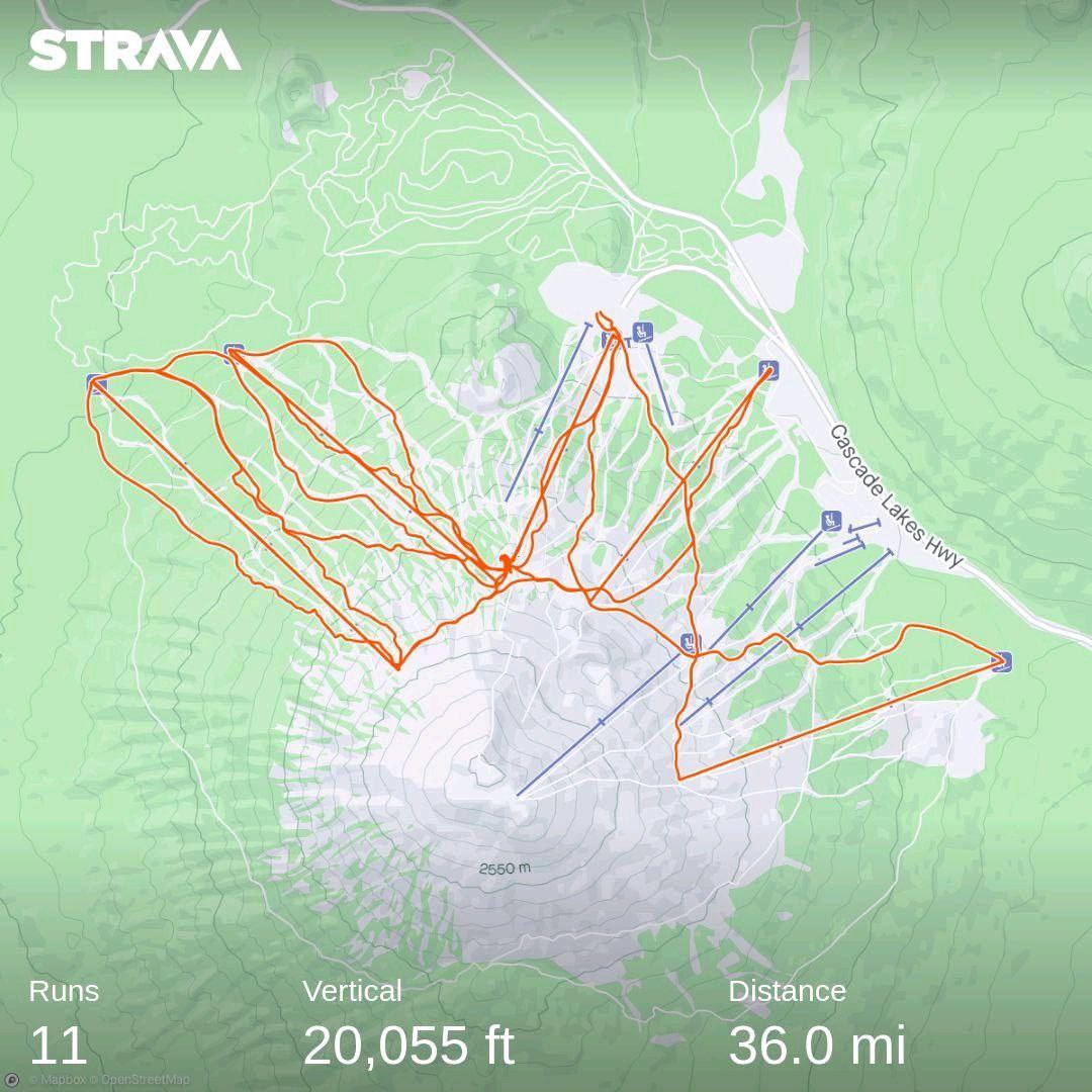
The place became deserted as Superbowl was heating up, but the weather didn’t get any better. We headed back down after 3.5 hours, with only 11k of vertical.
Day 3
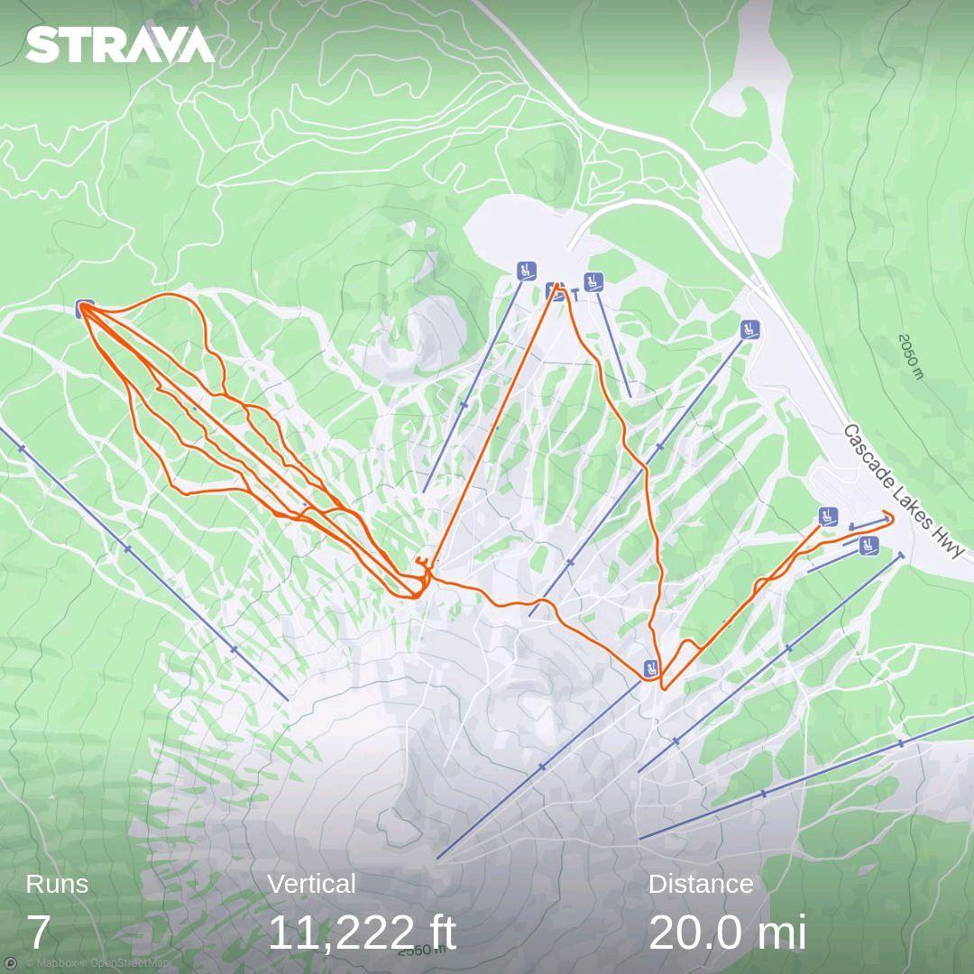
The weather was not a lot better, but the snow that had fallen overnight made me call a rare No Friends on Powder Day alert. I spent the entire time by myself, zooming down Outback and Northwest. The only stop was for lunch, and it was after an exhausting 3.5 hours of non-stop circling around. I had an absolute blast, between the absolutely perfect snow and the total lack of crowds. The lifties vibed with me, asking where I had come down from and where I was heading next. Everybody was having a fantastic time, especially since I was the only everybody in sight.
What particularly stands out about these reaches of Mount Bachelor is that there are trees everywhere, making for really amazing snowboarding. You pick a line down a glade and you can count on the soft pillow giving you the perfect amount of yield. Then, when you are tired from all the happiness, you can join back on the runs.
Northwest has some of the best terrain of any mountain I’ve ever been to. It’s wide open, it’s so hard to get lost, and it’s fairly even in pitch. You never worry that you might get stuck somewhere flat, you don’t have to be afraid of sudden cliffs appearing (maybe you do, I didn’t see any), you just look and descend, then get picked up by the lift and plot your next descent.
There was absolutely nobody on a Monday morning, a feeling I completely forget in 2024 Colorado, where every resort is always mobbed. I could just do my laps listening to my music, quiet enough that I could even hear the soft booms of snow hit by the board. It was like a snowboarder’s dream come true, alone with the mountain, but with an express lift to bring you back up instead of having to hike for hours for each five minute run.
Oddly, Pine Marten lodge was closed entirely. Apparently it’s not economical to run it outside of weekends, which makes the addition sort of useless. We had lunch at the West Village lodge - a really decent curry. Here, we split again. I had this idea that I wanted to try the Summit lift, since everybody had talked about it. But the lines on the weekend were insane, so I was turned off. Now, close enough to resort closing time, with the weather finally much better, I tried it.
Summit lift is amazing. It goes up to almost 9,000 feet, and from there you have views unrivaled. The top of the lift is a small house, the drop flat - to facilitate getting off even in windy conditions. The first ride was a little scary, mostly because it was still windy (but not foggy). But there was also a weird effect: the mountain is a cone, which means that the closer to the summit you get, the less mountain is around you. Usually, when you ride a lift there is the face of a mountain in front of you, completely closing off the view. That’s the case here, too - at first. But as you get to the actual summit, off to the side of the lift, there is the great blue nothing.
I didn’t have a lot of time, and I knew the lift was shutting down for the day. I thanked my randomly selected co-riders and descended toward the summit bowl and Cloudchaser. The whole ride is around 2700 feet, which is a lot of vertical for a single run.
Apres Day 3
With no crowds to slow us down and no games to watch, we headed into town. I wanted to find T-shirts and Tim wanted sushi. We found several stores in downtown Bend, but sadly nothing specific to Mount Bachelor. Bend is very proud of its logo, and all the good shirts we found were all about that. Sushi was largely unremarkable, but maybe we are very spoiled from our local offerings.
Day 4
The curse of the noob struck again. We could have snowboarded a fifth day with the Ikon Base Pass, but we had planned poorly and the fourth day would be our last. We had toyed with the idea of driving late, after a full or half day of boarding, but there was a storm incoming and we didn’t want to deal with that.
The day started with a visit to an extremely highly rated coffee shop by the roundabout entering town. I forget the name, mostly because it didn’t seem to merit the high rating. There was nothing special about the place - one of the areas of a business park - and the coffee was good enough, but nothing to write home about (which is why I didn’t write home about it).
You know when ratings for odd places are super high? For instance, I found that frequently the highest rated restaurants in any town are sandwich shops. And the highest rated coffee places end up frequently being drive through coffee carts?
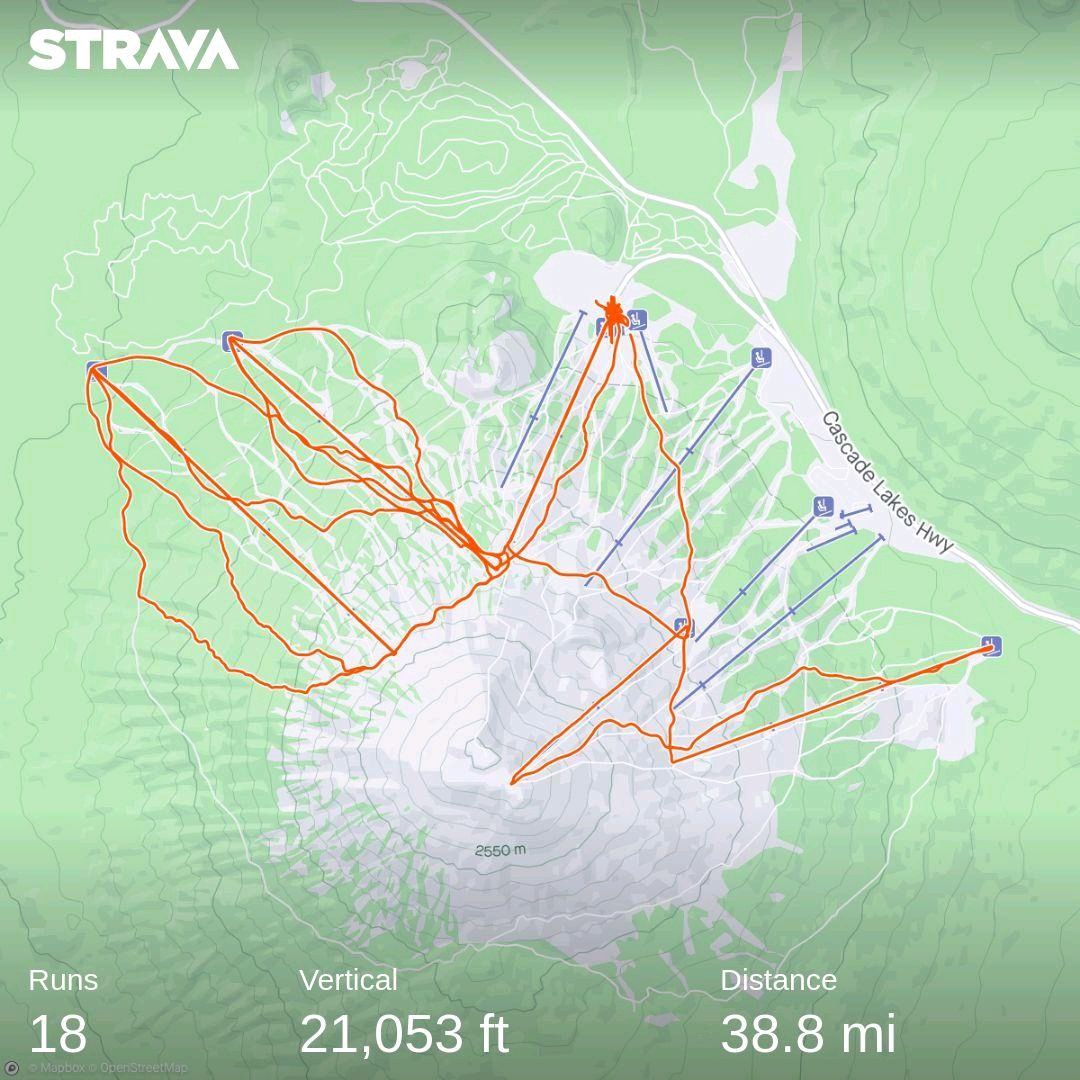
We made it up the mountain and parked with skill and confidence in the Sunrise parking area. From there, we took the local lift twice, trying to wait out the morning crowd on Summit lift. After two rides we saw our chance and we headed over. We headed up and took pics of the amazing surroundings, since the weather had turned perfect again. Then we went down. Tim got upset at me and we split, so I did a few loops on Cloudchaser, and then started moving back. I took Skyline, the six-seater, so I’d have done every lift at the resort, then we had lunch at West Village.
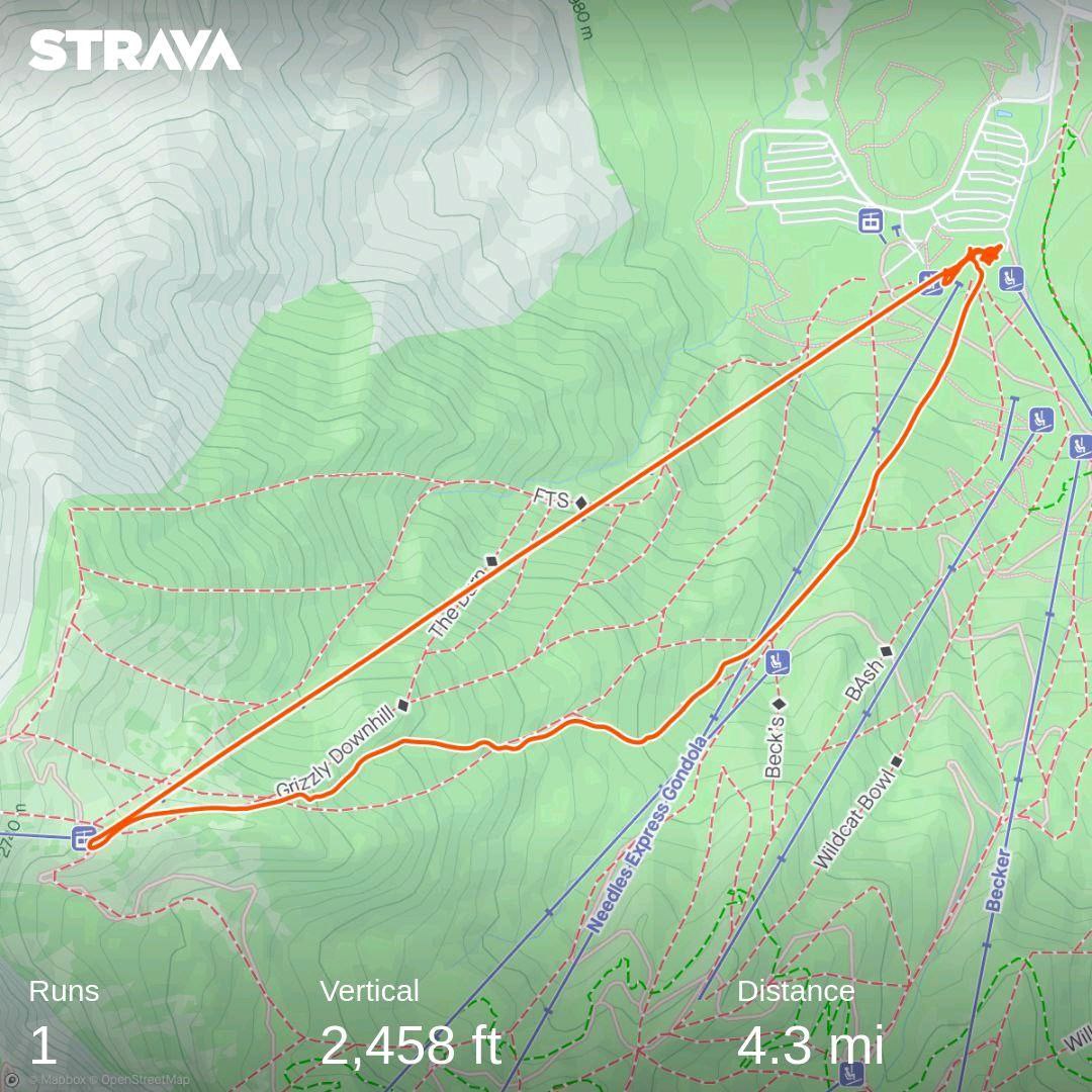
I had reserved the afternoon for a special treat: I had heard you can ride around the mountain from the summit. So I took the lift, decided to also do the summit “crater” (it looks a lot more like a broken off segment of the North-East side of the summit - watch out for the flat area at the bottom leading to the spout out). After that, the scary moment.
I got out and saw that I could, in fact, just drop down the back, South side of the mountain. I had already been told there are several rings of feeder runs that go back to “civilization”. The first, higher two are for ski traffic (that is, they have a steady incline you can ride), while the third one is used by dogsledders and hence flat. I knew I was going to hit one of them, and was little afraid it might be the third, the longest and requiring a hike. At least I hoped the information I just repeated was accurate.
The ride out was fantastic. The snow was fresh and deep and the entire mountain was a delight. I knew I had to traverse a lot at first, as horizontal as possible, because I wanted to get back to Northwest without having to do an endless feeder run. The more you traverse at high altitude, the more total angle you cover.
Eventually, I hit a cone-like feature. I stayed high to its right, but noticed the carved runs where it sloped away from the main mountain. If you get there and see it, it’s a good marker. If you are to the right/upslope, you are too high, as I found out. The feature is at the 8400 foot level, and you have to drop another 2000 feet to get to the base of Northwest lift.
I continued and hit a series of fins separating gullies. At this point, I should have started having more fun and descending the gullies with an eye to the right, crossing the fin (rocks and bushes), and making my way. Instead, I continued staying high up, which cut down a lot of the fun I could have had. I ended up slightly upslope of Northwest lift, which means I could descend down the lift line and have fun.
The reason I say it would have been better to descend more (and join the lift at the base instead of the top) is that it would have been a much longer ride. You see, a mountain that tops at 9000 feet has twice the circumference at 7000 feet than it has at 8000 (roughly speaking). So, by trending down more, I would have added a lot of rideable terrain. Keep that in mind if you repeat the feat, and I absolutely loved it.
I thought the 2700 feet from the top of Summit to the bottom of Cloudchaser were a lot, but since Northwest is way lower than Cloudchaser, this entire circle was not only a lot of distance, but also a lot more vertical: some 3300 feet or so.
After that, I reconnected with Tim and we did a few loops of Outback. The fun was amazing and we headed back home, prepping for the return trip.
Notes on Summit Expedition
You’ll notice the prominence of warning signs at the top of Summit lift making it clear that the circle expedition in either direction is dangerous and risky. The main problem is that there is no way to monitor this entire side of the mountain, and hence if something goes wrong, you have no way to recover. Stuck in deep powder? Fell off a rock? Bruised a rib? Broke a binding? You are entirely on your own. I had no signal the entire time, and I knew that if I messed up I’d be alone and lonely for a long while.
Mount Bachelor makes it clear that the area is full of surprises, and that you should not attempt it solo like I did. At the very least, you must inform someone of your plans, so that rescue can be attempted if you don’t make it back in time. Beware particularly of the South side, which could have a lot thinner snow coverage. But the West and East come with their own risks: the West being very windswept and the East generally steeper and more unpredictable.
It’s all doable, but you should be planning ahead. If you can, get together with a local expert, and don’t try to ride if you are not familiar with the variable conditions of ungroomed terrain. Beware of avalanche risks and get information about dangers ahead. Just don’t be the daredevil that jumps down the run hoping everything goes well but without knowing what’s what, please. Your life and health might depend on being informed and prepared, and the rescue operation is risky and costly.
Driving to Utah
As a bonus, and knowing we wouldn’t make it to Colorado if we left after a full or even half day, we decided to book a stay near Ogden, UT. There were two resorts nearby, and one (Snowbasin) was on the Ikon Pass.
The drive itself, ahead of the storm, was just the inverse of the drive to Bend. We even stopped at the same coffee shop in Ontario. In Oregon, we noticed that Bend is quickly becoming ritzy and glitzy, with sky-high property prices and luxury everything. On the way, there was Burns, which started looking like the budget capital of the Eastern Oregon recreation area.
We drove with no problems until we hit Mountain Green off I84. There, a quick drive on the business loop and we were at a fancy development with large mansions. We would be staying in the casita of one of them.
We were not prepared for what came. The casita was enormous. The rooms were large, the kitchen huge, the TV covered an entire wall. We were absolutely floored. There was even an elevator to get into the place!
The drive had been about 4.5 hours. Not enough to set us back, but enough for the combination of Valentine’s Day and the desire to be fresh on the mountain to keep us indoors.
Snowbasin
According to the map, it was under 20 miles from our casita to the lifts. We were up early enough and drove, but realized quickly that the storm we fled from had caught up to us. We were driving in hellish conditions, on wet snow that was still falling heavily. By the time we hit the turnoff to the resort, road conditions had gotten so bad that drivers were slipping off the road left and right. We had a Mustang ahead of us that couldn’t move and had to give up on the side of the road, and a minivan that barely made it up, having to start zig-zagging for purchase whenever the road had any upslope.
We made it into the parking lot and walked up to the lodge. Which was the first surprise of the day: the lifts were closed because of avalanche mitigation efforts and the lodge was packed. And the lodge itself was massive and very posh. It reminded me very much of Beaver Creek in Colorado, with giant tree trunks being the pillars holding up the place, and tapestries covering the walls. The food was amazing, the drinks (coffee) were amazing.
Finally, the lifts boarded. We had no idea about the mountain, but we had heard that John Paul Express was the place to be, so we headed over there.
Big mistake. Visibility was near zero, the mountain was crawling with people, 18 inches of the heaviest concrete snow made navigating impossible. We had no idea where the runs were and got immediately separated. It took me, according to Strava, 20 minutes to climb down a paltry 2500 feet, the slowest descent I ever attempted. I had no idea where I was going, I couldn’t see anything, and the snow was so heavy, even turning in it was impossible. The only safety was in the groomed runs, but I didn’t even know how to get there.
Tim fared even worse, losing himself to the mountain and coming down to the lift a full 15 minutes after I did. I was worried sick and incredibly relieved when I finally saw him stomping towards me, as angry as I’ve ever seen him.
We decided to pack and get out of the resorts, deciding the spend the rest of the day in our casita.
The Drive Home
Next morning, an easy drive first. When we went the other way, the drive from Rock Springs to Ogden was the slickest part. Now, we cruised happily into Wyoming with not a care in the world. We stopped in Rock Springs for gas and coffee, hitting another local spot we liked a lot, Nell’s Coffee on Powerhouse.
After Nell’s, all hell broke loose. The freeway was in different shades of iced over, and drivers seemed to be confused whether to drive like it was a skating rink or a normal Sunday afternoon in August. It was slick, it was scary, and people behaved like perfect idiots.
I thought many times over maybe I should give up and rest, but we still had to deal with the storm coming from our back, so it would only get worse.
Conditions didn’t improve until we got into the Laramie area. We now had to decide whether to take the “shortcut” through Fort Collins or drive to Cheyenne and take I25. We opted for the former, since the weather to the East looked worse than to the South.
What we got was a rural highway with crazy people driving. There was a news report about a vehicle with the swim team of University of Wyoming crashing and killing the entire team on this rural stretch, and I can absolutely see why. Mainly, it’s about the road evidently not being built for the heavy traffic it carries - turnoffs are poorly marked and provide no turn lanes (for no reason but cost, as far as one can tell), rural roads cross this very busy highway without markings. It’s a mess, not made any easier by the heavy fog we were driving through in places.
We made it back to Fort Collins, and then I25. Hit home, took a shower over an hour long just to get the cold and grime off.
Conclusions - Driving
I don’t like flying any longer. Airlines and airports have gotten increasingly annoying about everything from the cost of bringing snow equipment to the ridiculous shenanigans at check-in and security. The planes are cramped, the service minimal. Transportation to Denver Airport is terrible, despite the existence of a direct train from Union Station.
But an 18 hour drive is not fun, either. Sure, when you drive you see landscapes you wouldn’t have when flying. You can bring all the equipment you like, knowing it’s all safe in the trunk and will show up at the destination. It’s cheaper overall. But it’s also driving on potentially deadly roads, in variable conditions, making you tired.
We snowboarded for four days. One day was lost to the 18 inch miracle storm in Snowbasin, a second day at Mount Bachelor because we planned to snowboard but then fled an incoming storm. We drove for four days. That was stupid. In hindsight, if driving, I would have made sure to either drive an entire day or take a true half day of riding. But 18 hours, the total drive time, is definitely too much for a single day.
Conclusions - Mount Bachelor
To get to the Bach, we had to drive past at least a dozen world class ski resorts. I wondered to myself if it would be worth the trip, when we could have just braved the hour to Keystone or Copper, or the hour and a half to Vail, or preferred Steamboat, Telluride, Crested Butte, Park City, Snowbird, and the other many resorts much closer to us and much more famous.
I thought so until the first day on the mountain. Then I knew that Mount Bachelor will always be one of my favorite ski resorts. There are a lot of reasons: the drive from Bend is much shorter than anything around here; the mountain itself is as beautiful as any other I’ve seen from a ski resort; the infrastructure is amazing; the crowds friendly for the most part, as are staffers; the snow is famous, the runs amazing, the trees so much fun. Even the food played ball, between the tenders and the curry and the espresso.
It was absolutely worth it. I kept thinking I was mad that I hadn’t moved to Bend when I chose Denver instead. In the end, I think I made the right decision (as Denver has a lot more to offer long-term than Bend), but I’d recommend anyone visit the Bach.